Showing posts with label USA. Show all posts

Saturday, May 18, 2013

Year to date Severe Thunderstorm Watch's and Tornado Watch's in the USA

 The images below show year to date of Severe Thunderstorm Watch's and Tornado Watch's


Severe Thunderstorm Watch's


Tornado Watch's

Sunday, April 7, 2013

Damaging East Downslope Winds Likely

 Models have been advertising this wind event for some while now, there is still some uncertainty as when this event will start with one model starting it Monday afternoon and the other early Tuesday morning.
 The graphic below show the possible wind gust's @ 2am Tuesday, as you can see it is showing gusts between 65-75 KT (75-85mph) at this time.
 
model image 


 I will do an update later this evening as more models come in, this particular model runs twice a day at noon and midnight, I would suspect a High Wind Watch will be issued this afternoon, and then upgraded to a Warning on Monday!  

For past event's click on the link below.


https://encrypted-tbn2.gstatic.com/images?q=tbn:ANd9GcR4RVC5GeXmK-U-faM7Adz6A2bi8mDTvbD9e22sk8AV_C1F2DgTLQ


Sunday, January 27, 2013

The Inversion is Gone, but Heavy Snows in Tap


      As you can see from the picture below most of the smog and junk from the last 2 weeks is out of here, as if we have not  payed the price with this inversion already we are going to add insult to injury and bring in a potent snowstorm today.
   
 As you can see the NWS has winter weather advisories and warnings in place.


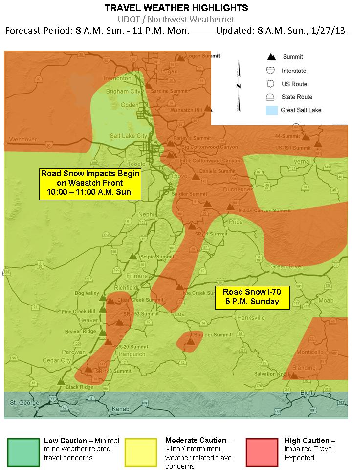
Here is UDOT'S take on the approaching storm


So lets get down to business with snow amounts, today-tonight's storm keeps trending snowier in all models, and slows the front down across N. Utah that is why the nws has upgraded the nothern wasatch mountians and valleys to a warning, click here to visit the nws page current thinking for the valleys is that Farmignton north will get the goods prob. anywhere from 5-8"+, but if the front stalls a little bit further south then places like Bountiful and Possibly SLC will receive more, for the rest of the Wasatch Front my guess would say 3-6 inches, but as i said the last 2 models have generated quite a bit more, so don't be surprised to see 8+. 

A bit of a break Monday afteernoon and night then the 2nd storm moves in, this will be a diffrent type of storm which will be a warm advection, which is when there is no front associated with it, just lifting of the low levels of the atmosphere, these events are hard to predict amounts but current thinking is 3-6"+ in the valleys, with a another light snow event on Wednesday. Enjoy


As for the Wasatch Mountains, looks like a good 8-14" with this 1st storm, them a 5-10" with the 2nd storm on Tuesday which adds up to 1-2' feet of snow, great skiing days on Monday-Thursday!


Saturday, December 22, 2012

Fresh Pow for Christmas in Utah

      Systems continue to push into the west coast as the large parent low spins off the Pac NW coastline. Everything still on track with previous forecast. Main change is that short-range models are now within range and bringing in the details, so we have greater confidence in snowfall amounts. We will have breezy conditions today with a warm southwesterly flow ahead of the approaching systems. This flow should scour out the cold pools (inversions) in the valleys and allow them to warm up. Clouds should also be on the increase this afternoon
.
      Tonight we have the first weak wave bring mostly mountain snow showers after about midnight. This will primarily affect the mountains north of I-80 and could bring 1-3″ of fresh snow for tomorrow. We will then see a break in the action Sunday afternoon / evening as the next, more potent, system enters the area.
This stronger system will bring snow to the area late Sunday night and the snow should continue all day on Monday before tapering off on Monday night. The system is currently progged to track perfectly to bring the entire Wasatch a good period of both frontal and post-frontal snowfall. This is by no means a major snowfall for the Wasatch, but everything looks good for a decent period of snow. The lower valleys might start as rain or rain/snow mix early Monday morning before changing to all snow as the front approaches late Monday morning. Valleys can expect 1-4″ of snow. The Wasatch should see .75-1.25″ of QPF and average snow ratios of 15:1 — this translates to about 10-18″ of snow for the high elevations. Not too shabby! The other concern will be travel conditions around the state, with Christmas eve being a busy travel day this could hamper travel to grandmas house. As of now this is what  UDOT is saying: ****Please check back Saturday afternoon for road weather impacts as a stronger storm moves through Utah Sunday evening through Monday (Christmas Eve).  Valley routes and the I-15 corridor are expected to see periods of light road snow while mountain routes will see moderate accumulations of road snow Sunday evening through Monday (Christmas Eve).***Click Here to go to UDOT's Road Weather Alerts

Here is the latest model-generated snowfall forecast for the Western CONUS through Christmas day:

Snowfall forecast

      We should clear out on Christmas Day for blue bird conditions. Wednesday we’ll see the next system approach with snow likely Wednesday night-Thursday night, perhaps lasting to Friday. At this time this looks like a moderate storm. Great news for all the holiday skiers who are traveling to Utah for some freshies. But it could cause some travel headaches.

     The Cottonwoods and PC continue to do alright this year and are just above average snowpack, but the Northern Wasatch is struggling at less than 50% of normal in places so lets hope we can get some good snows going in their direction as well.


Saturday, December 15, 2012

Plenty of Snow in Utah, More to come !

   WOW what a storm a Powder day on tap for sure!  Looks like the Cottonwoods have close to a foot and Park City area  received 5-10″. Wasatch front Valleys have seen anywhere between 1"-6" and benches between 4"-12". And it is still snowing . . Additional accumulations of 1-3″ in the Cottonwoods and PC is likely. Here’s a look at the Snowbird Snowcam (which measures up to 16″):

Pic. courtesy  Sheryn Shaw on Saturday morning
birdcam
  
Our next storm will arrive on Sunday and as i stated in my last post, we will have to watch this one and of course it looks a little stronger than before,  it still looks like it will move in for Sunday through Monday. This is an advection precipitation event and favors the Northern Wasatch. NWS has hoisted a Winter Storm Watch already to highlight this. This system looks much better now than it did the other day, so we’re feeling optimistic. Another 10-20″ can be expected for Sunday-Monday in the mountains with up to 2 feet in favored locations north of I-80. Wasatch front Valleys should receive another 1"-3" + ,benches should receive 2"-5" +. Lots of Snow! Monday should be an awesome powder day!

      The next system moves in late Tuesday and drags a front through the area early Wednesday morning. This system is fairly potent as well as very cold. There will be potential for lake effect snow behind the front on Wednesday.  We’re looking at potential for additional significant accumulations of 1'-2' + for the Wasatch mountains with wasatch front  valleys 6"+ and benches 12", hopefully the models do not flip flop on us and it produces a BIG snow event, Keep your Fingers Crossed! 

     After Wednesday it looks like we’ll have at least a 4 day break with the possibility of urban Fog, next chance for snow will be Christmas eve or Christmas day. But let’s focus on the a very snowy short term for now!

Friday, December 14, 2012

Powder Days Ahead

Who is ready for some more POW

     Tonight-Saturday the Wasatch mountains should receive 6-12" of snow and the valleys might squeeze out 2" while the benches might receive 4".


      Sunday -Sunday night was once a pretty good looking storm according to models a few days back, now most likely a warm advection type storm, which means no front crossing the area, so looks like the Wasatch will receive another 4"-8" of snow and the valleys maybe another 2"-3" and benches 3"-5" Poss. more will have to watch this one.


Tuesday-Wednesday still looks like a very potent storm for the area, a strong cold front blasts thru around the evening commute tuesday, might have to watch this one as temps will fall in the 20's behind the front so accumulating  road snow and ice will be a good bet, right now i am thinking 1'-2' + for the Wasatch mountains with valleys 6"+ and benches 12"+.  Plus there is a chance of DLE (dreaded lake effect ) Wednesday morning.

If you have not tuned up the Snow blower now is the time!


Stay tuned will update tomorrow! 


Tuesday, December 11, 2012

White Christmas ?


   Tomorrow will be clear but winds will be on the increase ahead of the next system.  This system is a cutoff low that will drop down the west coast on Wed before ejecting inland over So. Cal, N. Arizona and S. Utah on Thursday and Friday.  This will bring high elevation snow to S. Utah where they desperately need it.  The Wasatch will just see a chance for mountain snow showers on Thurs and Friday.  A secondary wave will drop in from the northwest Friday night and give Northern Utah a chance for more widespread snowfall.  Still, amounts should be light with just a few inches in the mountains.

      Saturday should be the break in the action before a larger, colder trough enters the area on Sunday.  This storm right now is timing for a late Sunday through Monday.  Still questions about its overall strength but it has potential to be decent.  We’ll continue to watch it.  Models agree on a break for Tuesday of next week with another system dropping in on Wednesday with another system possible for the weekend leading up to Christmas.  Definitely has the potential to be a great little pattern for us in Utah and throughout the Western U.S.
                 
         Below are forecast models for Sunday the 16th and Wednesday the 19th, and i also put Christmas Day in there also, this is way far out there but models for the last 3 days are showing a storm for Christmas, let keep are fingers crossed and hope it brings us a white one!

Sunday the 16th @ 12pm

Sunday the 16th @ 6pm

Wednesday the 19 @ 12pm

Christmas Day @ 12pm

Monday, December 10, 2012

Utah to continue to receive some POW!


 A low pressure system will cutoff from the general flow and drop down the west coast over the next couple days before ejecting inland.  It will have a lot of energy and moisture to work with, but looks like it will track over northern Arizona.  A bummer for us in the Wasatch as we’ll likely see very little snow from this, but good news for the mountains of Southern Utah and Northern AZ that really need some snow.

Attention then turns to potentially stronger systems that may bring some great skiing and riding to the area leading up to Christmas (or the end of the world, depending on your perspective).  The eastern pacific ridge retrogrades westward, allowing for the storm door to open up for the west coast and areas inland (Utah).  The first of these systems is being handled differently by each model. The GFS is weaker with the system and keeps it mostly in the northwest with just a few showers for northern Utah this weekend, it does eventually drop the system into the Great Basin, but not until early next week.  The Euro and GEM are similar with the strength position of the system, but differ on general timing of the heaviest precip.  The GEM wants to bring heavy snow to the area starting  late Saturday, while the EC holds off until Sunday.  Both solutions are stronger and farther south with the system than the GFS.  General consensus in the meteorology world is that the EC and GEM are the better models with this particular feature based on better ensemble support and a better recent track record.  But the stubbornness of the GFS to come around over the past few days keeps confidence low.  We believe that we have a decent shot at a  significant storm on approximately Sunday the 16th if these trends hold.  Snow levels will likely be at valley floors for this system as well.  I told you all to just hang on till mid-month… fortunately mother nature provided some frequent small storms to make the wait a bit easier.


The synopsis is we will have a break Tuesday and Wednesday, a chance for light snow Thurs/Fri as the cutoff low tracks to our south, and then a chance for a better storm this weekend.
Long-range outlook still looking good with the progressive pattern continuing and systems dropping in for the next couple weeks.  We are either going to have a nice snowy end of the world on the 21st or a great holiday ski season.   I’m okay with either.

We’ll keep you posted this week on how the weekend storm is looking….


Tuesday, October 23, 2012

Possible Snow Tonight ?

TUESDAYS MORNING COMMUTE
 
 
       ANOTHER ROUND OF WINTRY WEATHER IS EXPECTED TO DEVELOP LATE  
  TONIGHT INTO WEDNESDAY. A STRONG PACIFIC JET WILL DIG FURTHER  
  AND CONTINUE TO SUPPORT A NEGATIVELY TILTED TROUGH. A SWATH OF  
  STRONG FRONTOGENESIS WILL OCCUR SOMEWHERE ACROSS NORTHERN UTAH WHICH  
  WILL LIKELY SUPPORT A BAND OF HEAVY SNOW. VERTICAL MOTION THROUGH  
  THE DENDRITIC SNOW GROWTH LAYER WILL SUPPORT LARGE DENDRITES AND  
  SIGNIFICANT SNOW RATES. THE QUESTION IS WHERE WILL THIS BAND  
  DEVELOP? CURRENT MODELS IN GOOD AGREEMENT THAT IT WILL DEVELOP  
  BETWEEN WENDOVER...THE WASATCH FRONT AND EVANSTON. THIS COULD AND  
  LIKELY WILL SHIFT SOME. BUT WHEREVER THE BAND DEVELOPS...SIGNIFICANT  
  IMPACTS ARE EXPECTED. DEFINITELY CHECK LATER FORECASTS AS THE  
  WEDNESDAY MORNING COMMUTE COULD BE SIGNIFICANTLY IMPACTED.  
   
  ALSO DURING THIS TIME...THE SURGE IN COLDER AIR FROM NORTH TO SOUTH  
  COULD SUPPORT A LEGITIMATE LAKE EFFECT SNOW BAND EXTENDING FROM THE  
  GREAT SALT LAKE INTO THE TOOELE VALLEY AND WESTERN SALT LAKE VALLEY. 
   
  ANOTHER RELATIVE BREAK IS EXPECTED WEDNESDAY AFTERNOON AND EVENING  
  AS THE NOSE OF THE JET PASSES THE REGION AND THE AFOREMENTIONED  
  PROCESSES DECAY. SHORT RANGE ENSEMBLES INDICATE WIDESPREAD AFTERNOON  
  INSTABILITY SO MENTIONED THUNDER AGAIN WEDNESDAY AFTERNOON. 
   
  THE THIRD ROUND OF WINTRY PRECIPITATION IS EXPECTED THURSDAY. WARM  
  ADVECTION IN THE MIDDLE ATMOSPHERE SHOULD SUPPORT A BAND OF  
  PRECIPITATION FROM SOUTHWEST TO NORTHEAST ACROSS MUCH OF NORTHERN  
  AND CENTRAL UTAH. TRAJECTORIES OFF THE GREAT SALT LAKE SUPPORT THE  
  THREAT OF LAKE EFFECT SNOW INTO THE SALT LAKE VALLEY AGAIN THURSDAY  
  MORNING. ENJOY


Monday, October 22, 2012

Wet Week Ahead


Everything is set and ready to go.  Models continue to be in very good agreement for the most part through Thursday. Utah is primed for its first winter like pattern.

           Looking at all the charts this morning I’m feeling comfortable with the forecast which went back and forth on the strength of these systems all last week but settled in on a solution on Friday and for the most part has stayed on that solution since Friday.
       Today we’ll have the first of the stronger waves of precipitation approach the area.  All models now don’t show the bulk of the precip arriving until tonight, but showers will still be possible all day with warm, moist flow over the area.  Tuesday morning, snow levels will start to finally lower below 8,000 feet, possibly falling as low as benches and even valley floors by Tuesday evening.  Snow will start accumulating in the mountains on Tuesday and it should snow off and on through Thursday as reinforcing shots of energy rotate into the region.

       Wednesday will be colder as the cold pool of the parent Low works its way into the Wasatch.  We should see snow levels fall all the way to valley floors according to the 12z run of the NAM (computer model).  Grassy surfaces may see light accumulations but warm pavement temps should keep road accumulations minimal.
By Thursday night, we’ll start to dry out as a ridge builds in for next weekend, though temps should remain cool.

Accumulations:
      Right now we’re still thinking 8-16″ total above 8,000 ft for Monday-Thursday.  Mountain valleys will probably see 4-8″.  Benches of Wasatch could see a couple inches later in the event.


Monday, October 15, 2012

Possible Major pattern change

After not checking the models for the last 48 hours, I was excited to see that the latest 18z run of the GFS and the latest run of the Euro both show a potential major pattern shift for next week.   We generally take these long range models with a grain of salt as anything beyond 10 days is very unreliable, but it was worth noting.  Well it seems that this time the charts were on to something.  Models show a much colder, more organized system diving into the Great Basin late next weekend/early next week.  It is still very early, but this is the type of winter storm that could bring snow all the way down to the lower valleys with decent, lasting snowfall for the mountains.  The latest versions of the CFSv2 continue to indicate this pattern change in today’s run.  Here is the current forecast for the week of Oct 21-27:


As you can see, it depicts a deep moisture tap taking aim at the entire West Coast of the U.S., the type of pattern that is conducive for good Utah snowfall.  It is still very early to get into any details but it does seem as if there may be a series of systems to affect the area after the initial system.  Something to keep an eye on for sure, as it could be the type of pattern that goes a long way to getting the Utah ski season underway.
However this ends up playing out, we’ll keep you informed.  Hopefully the models continue with this trend instead of backtracking as they did so often last year. Right now, we are leaning towards the colder, wetter solution. 18z GFS seems to reflect this as it trended slightly farther south than previous runs. Of note, if the colder solution verifies, we could be looking at snow down to SLC valley floors–lake effect snow is also a distinct possibility as GSL surface temps are still relatively warm. Still very early but this is an exciting trend that could go a long way to getting us all on the mountain. Cross your fingers that the models don’t backtrack.

Tuesday, October 9, 2012

Rain looking likely Thursday-Friday

       A LOW IS PROGGED TO TRACK ALONG THE CALIFORNIA COAST THROUGH 
  TOMORROW BEFORE QUICKLY MOVING EASTWARD BEGINNING 
  THURSDAY...MAKING ITS WAY ACROSS SOUTHERN UTAH ON FRIDAY. MOISTURE 
  WILL BE ON THE INCREASE OVER SOUTHWEST UTAH TOMORROW...ALLOWING 
  FOR A FEW SHOWERS OVER THE TERRAIN. INCREASED MOISTURE ALONG WITH 
  INCREASED INSTABILITY AHEAD OF THE LOW WILL ALLOW FOR BETTER 
  COVERAGE OF CONVECTION OVER SOUTHERN UTAH ON THURSDAY. INCREASED 
  CLOUDS WILL ALSO RESULT IN A DECREASING TEMPERATURE TREND FOR THE 
  SOUTH BY THURSDAY. MEANWHILE...MAXES IN THE NORTH WILL BE AS HIGH 
  AS 10F ABOVE CLIMO AWAY FROM THE CLOUDS AND CONVECTION. 
   
       THE SYSTEM IS EXPECTED TO PUSH ACROSS SOUTHERN UTAH 
  FRIDAY...ALLOWING PRECIPITATION TO BECOME MORE WIDESPREAD AND 
  SPREAD INTO NORTHERN UTAH BY FRIDAY AFTERNOON. ABUNDANT CLOUD 
  COVER AND COOLER 700 MB TEMPS SHOULD BRING TEMPS BACK AROUND CLIMO 
  OVER THE NORTH...AND UP TO 10F BELOW THOSE VALUES OVER SOUTHERN 
  UTAH. PRECIPITATION WILL MOSTLY FALL AS RAIN...WITH SNOW POSSIBLE 
  AT HIGH PEAKS ABOVE ABOUT 9000 FEET. THE LAST FEW MODEL RUNS HAVE 
  SHOWN VERY GOOD RUN-TO-RUN CONSISTENCY...AND GLOBAL MODELS ARE 
  SHOWING BETTER THAN USUAL AGREEMENT...SO FORECASTER CONFIDENCE IS 
  HIGHER THAN USUAL.  
   
  MODELS INDICATE THE STORM SYSTEM WILL QUICKLY EXIT THE AREA ON 
  SATURDAY...ALLOWING FOR A DRIER NORTHWESTERLY FLOW TO DEVELOP. 
  COMPUTER MODELS INDICATE A RIDGE WILL GENERALLY DOMINATE THE WEATHER 
  PATTERN THROUGH EARLY NEXT WEEK...THOUGH A TROUGH MOVING OVER THE 
  RIDGE WILL WEAKEN IT AND GRAZE NORTHERN UTAH DURING THE DAY MONDAY 
  BEFORE HIGH PRESSURE BUILDS BACK BEGINNING AT DAY 7.  
   
 ../GemPakTier/MagGemPakImages/nam/20121009/18/nam_namer_072_sim_radar.gif


Thursday, October 4, 2012

October Outlook


Short term:
The first part of the advertised cool down began yesterday with high temperature about 5-10 degrees lower than they were on Tuesday.  Today is another near average day before temps will dip below average tomorrow through the weekend along the Wasatch Front with the arrival of a reinforcing shot of cold air that will push slightly farther west than yesterday’s.  We, however, will see nothing in the way of precipitation, as all of that action is well to our east.  A few more clouds tomorrow and light breezes is all that will accompany the cooler temperatures.  Night time temps tomorrow night through the weekend will dip below freezing in mountain valleys and some of the colder low valleys as well. Time to cover up or harvest the plants.
Next week, the closed cut-off low pressure system that has been sitting off the California coast will gradually move inland.  Over Southern California, Southern Utah, and Arizona.  Not too much dynamics or moisture associated with this system but it will bring us a slight chance of showers–with the best chance for precip mostly to our south.  The timing on this looks to be about Wednesday of next week.  Southerly flow that develops ahead of the low may warm us up back to near average by Tuesday


Long term:
Everything beyond the next 7 days is very vague at this point but there is nothing to suggest that the blocking high pressure ridge parked off the coast of British Columbia will be going anywhere anytime soon.  So our best chances for snow will remain with cut-off low pressure systems or weak, cool systems that periodically drop down the east side of the ridge.  El Nino, which for a couple weeks, was looking a little stronger in the models, now looks weaker again.  The CPC has now given only 55% chance of development.  I was never as sold on it’s development as they were so I’m not too surprised.  I also believe that an ENSO neutral year or a very weak El Nino is better for Northern Utah’s chances at seeing average or above precipitation.  La Nina has a tendency to favor the Northwest, El Nino – the southwest, but an ENSO neutral year often aims the jet stream more at the mid-latitudes (including the Wasatch).  Teleconnections begin to play a significant role in our weather this time of year, but as of now, most of those are in neutral states and forecasted to stay that way for at least the next ten days or so.  We’ll keep an eye on those as well as the MJO over the next few weeks to see if they show signs of livening up, whether good or bad.
For the month of October, it’s looking mostly dry until at least mid-month.  After that, the CFSv2 suggest near average precipitation through the end of the month. So overall, I think we’ll be below normal precip-wise and near normal temperature-wise for the month barring some drastic change in the pattern.  Not too much excitement as of yet, but remember, things can change in a hurry once the Pacific steps on the gas.


 As far as seasonal outlook, not much reason to change my original snow forecast for the season of about normal.  If a weak El Nino does indeed develop, the southern parts of Utah may be more likely to jump above average with the North slightly below.  But I’m guessing that El Nino will be mostly a non-factor for us this winter so most areas of Utah will have equal chances of seeing above/below average snowfall.  Sounds a bit like a cop-out to say just an average year, but the best we can do is call it as we see it, and right now there isn’t anything out there to suggest otherwise.  Besides, I think after last winter, we’d all be quite happy with an average snow year, right?

El Nino vs. La Nina influnces on the Untied States


According to NOAA’s Climate Prediction Center, weak El Niño conditions may develop this fall. How might a full-fledged El Niño event this winter influence weather where you live?
Years of monitoring and studying El Niño and La Niña events have helped scientists better understand how these seesawing warm and cool cycles in the tropical Pacific typically influence climate and weather patterns throughout the United States. This information can be particularly useful to farmers and water managers.
El Niño and La Niña are particularly influential in the winter. These maps show the difference from average December-February temperature and precipitation averaged over 22 El Niño and 19 La Niña episodes that have occurred in the past 60 years.
In the top row, shades of red indicate areas that were up to 3 degrees Fahrenheit warmer than average while shades of blue indicate areas that were up to 3 degrees cooler than average. In the bottom row, shades of brown indicate areas that received up to 2.5 inches less than average precipitation while green indicates up to 2.5 inches more than average.
During El Niño events, the easterly trade winds that blow across the tropical Pacific Ocean are weaker than usual and sea surface temperatures in the central and eastern Pacific become warmer than usual. An outcome of warmer waters is increased thunderstorms in the eastern tropical Pacific, contributing at times to well above normal precipitation on the West Coast. El Niño events also increase the odds of unusually wet and cold winters across the southern tier of the United States, while the Pacific Northwest tends to experience milder winter temperatures than usual.
During La Niña events, the pattern is typically reversed. Sea-surface temperatures in the eastern tropical Pacific are cooler than normal. The polar jet stream tends to shift northward over the central Pacific Ocean, increasing the likelihood of wetter- (or snowier-) than-normal winters in the Pacific Northwest and colder temperatures in much of the western half of the country. The meandering jet stream also typically leads to dry conditions and above-average temperatures in the southern tier of the country.
Maps by NOAA climate.gov team, based on data provided by Michelle L’Heureux, NOAA Climate Prediction Center. Caption by Caitlyn Kennedy. Reviewed by Mike Halpert, NOAA Climate Prediction Center.