Showing posts with label Snow. Show all posts
Friday, March 22, 2013
Lake Effect Very Likely Tonight
Conditions are excellent for a lake effect event tonight and early tomorrow: cold air, relatively warm lake water temps, decent moisture and instability. It’s the weather nerd in me that is fascinated to see how this develops tonight. The lake effect band may start close enough to the Cottonwoods to drop more snow up the canyons, however, I’m thinking it may migrate away from the Cottonwoods and closer to the Oquirrhs by later tonight. It will be interesting to see how this lake effect band develops. If we can get it just right, we could see decent accumulations.
Labels:
lake effect,
salt lake city,
skiing,
slc,
Snow,
spring,
utah,
wasatch,
weather,
Winter
Location:
West Bountiful, UT, USA
Tuesday, March 19, 2013
Rain then Snow for the Wasatch Front
Rain and snow will develop over the north Wednesday and gradually spread south though out the day. It should be a Rainy night in Salt Lake City.
It will turn much colder Thursday morning with the snow level lowering to the valley floors with
accumulations possible.
It will turn much colder Thursday morning with the snow level lowering to the valley floors with
accumulations possible.
Location:
West Bountiful, UT, USA
Wednesday, March 6, 2013
February 2013 Climatic Summary For Utah
It was a cold and Snowy February in spots around Utah, click on the link for detailed info from the National Weather Service.
Labels:
2013,
Climate,
cold,
February,
salt lake city,
slc,
Snow,
Temperature,
utah,
weather,
Winter
Location:
West Bountiful, UT, USA
Sunday, January 27, 2013
The Inversion is Gone, but Heavy Snows in Tap
As you can see from the picture below most of the smog and junk from the last 2 weeks is out of here, as if we have not payed the price with this inversion already we are going to add insult to injury and bring in a potent snowstorm today.
As you can see the NWS has winter weather advisories and warnings in place.
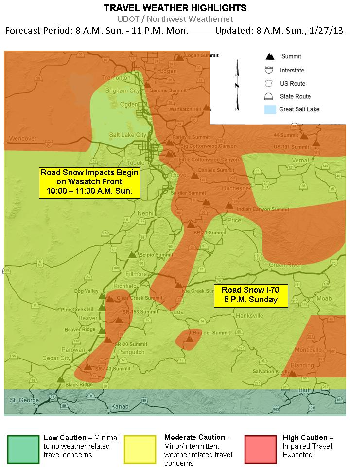
Here is UDOT'S take on the approaching storm
So lets get down to business with snow amounts, today-tonight's storm keeps trending snowier in all models, and slows the front down across N. Utah that is why the nws has upgraded the nothern wasatch mountians and valleys to a warning, click here to visit the nws page current thinking for the valleys is that Farmignton north will get the goods prob. anywhere from 5-8"+, but if the front stalls a little bit further south then places like Bountiful and Possibly SLC will receive more, for the rest of the Wasatch Front my guess would say 3-6 inches, but as i said the last 2 models have generated quite a bit more, so don't be surprised to see 8+.
A bit of a break Monday afteernoon and night then the 2nd storm moves in, this will be a diffrent type of storm which will be a warm advection, which is when there is no front associated with it, just lifting of the low levels of the atmosphere, these events are hard to predict amounts but current thinking is 3-6"+ in the valleys, with a another light snow event on Wednesday. Enjoy
As for the Wasatch Mountains, looks like a good 8-14" with this 1st storm, them a 5-10" with the 2nd storm on Tuesday which adds up to 1-2' feet of snow, great skiing days on Monday-Thursday!
Labels:
cold,
coldfront,
Inversion,
January,
mountains,
salt lake city,
skiing,
slc,
Snow,
USA,
utah,
weather,
Winter
Location:
West Bountiful, UT 84087, USA
Tuesday, January 8, 2013
Winter Driving Conditions Expected Thursday Eve.-Friday
There is a good chance of Very Dangerous Road Conditions for the Thursday evening commute as well as Friday morning's, below is a graphic from UDOT concerning this potential!
Statewide Road Snow Event
Thursday and Friday
Thursday and Friday
Snow amounts: Right now computer models are all over the place with regards to amounts, i will go with 4-8"+ in the valleys with the possabilty of much more if the DLE (dreaded lake effect ) sets up over a certain area, Benchs 6-12"+ and Mountains 1-2'+. Enjoy |
Location:
West Bountiful, UT 84087, USA
Sunday, January 6, 2013
Inversion's for a few more days then SNOW!
How cold has it been at the Salt Lake City Airport over the past week? Temperatures have
averaged 6 to 16 degrees below normal since December 29th. The biggest departure from
normal was January 5th, with the temperature averaging 16 degrees below normal.
![]() |
| Pic taken at noon on Sunday the 6th |
CLICK HERE FOR ANIMATED MAP OF LOCAL AIR POLLUTION
Alright now for the good stuff,
Attention turns to the next system which is timing its frontal passage for late Thursday/early Friday. We may start to see warm advection precip falling primarily in the high elevations ahead of the system as early as Tuesday. Accumulations should be light on Tuesday and Wednesday until the main system approaches on Thursday. As of right now this system is looking very solid on both the GFS and Euro. It doesn’t have the most moisture in the world, but it has a strong front, lots of cold air and instability behind the front, and relatively slow movement. Not comfortable at this point guessing exact amounts but at least a moderate storm is likely.
![]() |
| Thursday at noon it should be snowing at a good clip |
![]() |
| Sunday night's forecast |
The other effect this system on Thursday/Friday will have on Utah weather will be to scour out the inversions. Don’t think we’ll get enough air flow to do much damage to the cold pools on Tuesday and Wednesday, but by Thursday we should see the cold air and pollution start to blow out. Again, this system is of a cold nature, so don’t expect the valleys to warm up too much, but at least we’ll be able to see across the valleys again by Friday.
Hopefully this all pans out and relives us from this unhealthy air, we will update as we get closer! In the meantime head up and hit the slopes which still have great conditions, and believe it or not it is warmer at the resorts than the Wasatch front. Enjoy
Long range:
CFSv2 and long-range GFS and Euro point to possibility of us returning to ridging during the third week of January (15-21). Uber-long range models are hinting at this ridging breaking down during the last week of the month with the storm door possibly opening. Now this is all very speculative but it’s always worth noting. December long-range forecasts turned out to be pretty accurate so . . . who knows!
Location:
West Bountiful, UT, USA
Saturday, December 22, 2012
Fresh Pow for Christmas in Utah
Systems continue to push into the west coast as the large parent low spins off the Pac NW coastline. Everything still on track with previous forecast. Main change is that short-range models are now within range and bringing in the details, so we have greater confidence in snowfall amounts. We will have breezy conditions today with a warm southwesterly flow ahead of the approaching systems. This flow should scour out the cold pools (inversions) in the valleys and allow them to warm up. Clouds should also be on the increase this afternoon
.
Tonight we have the first weak wave bring mostly mountain snow showers after about midnight. This will primarily affect the mountains north of I-80 and could bring 1-3″ of fresh snow for tomorrow. We will then see a break in the action Sunday afternoon / evening as the next, more potent, system enters the area.
This stronger system will bring snow to the area late Sunday night and the snow should continue all day on Monday before tapering off on Monday night. The system is currently progged to track perfectly to bring the entire Wasatch a good period of both frontal and post-frontal snowfall. This is by no means a major snowfall for the Wasatch, but everything looks good for a decent period of snow. The lower valleys might start as rain or rain/snow mix early Monday morning before changing to all snow as the front approaches late Monday morning. Valleys can expect 1-4″ of snow. The Wasatch should see .75-1.25″ of QPF and average snow ratios of 15:1 — this translates to about 10-18″ of snow for the high elevations. Not too shabby! The other concern will be travel conditions around the state, with Christmas eve being a busy travel day this could hamper travel to grandmas house. As of now this is what UDOT is saying: ****Please check back Saturday afternoon for road weather impacts as a stronger storm moves through Utah Sunday evening through Monday (Christmas Eve). Valley routes and the I-15 corridor are expected to see periods of light road snow while mountain routes will see moderate accumulations of road snow Sunday evening through Monday (Christmas Eve).***Click Here to go to UDOT's Road Weather Alerts
Here is the latest model-generated snowfall forecast for the Western CONUS through Christmas day:

We should clear out on Christmas Day for blue bird conditions. Wednesday we’ll see the next system approach with snow likely Wednesday night-Thursday night, perhaps lasting to Friday. At this time this looks like a moderate storm. Great news for all the holiday skiers who are traveling to Utah for some freshies. But it could cause some travel headaches.
The Cottonwoods and PC continue to do alright this year and are just above average snowpack, but the Northern Wasatch is struggling at less than 50% of normal in places so lets hope we can get some good snows going in their direction as well.
.
Tonight we have the first weak wave bring mostly mountain snow showers after about midnight. This will primarily affect the mountains north of I-80 and could bring 1-3″ of fresh snow for tomorrow. We will then see a break in the action Sunday afternoon / evening as the next, more potent, system enters the area.
This stronger system will bring snow to the area late Sunday night and the snow should continue all day on Monday before tapering off on Monday night. The system is currently progged to track perfectly to bring the entire Wasatch a good period of both frontal and post-frontal snowfall. This is by no means a major snowfall for the Wasatch, but everything looks good for a decent period of snow. The lower valleys might start as rain or rain/snow mix early Monday morning before changing to all snow as the front approaches late Monday morning. Valleys can expect 1-4″ of snow. The Wasatch should see .75-1.25″ of QPF and average snow ratios of 15:1 — this translates to about 10-18″ of snow for the high elevations. Not too shabby! The other concern will be travel conditions around the state, with Christmas eve being a busy travel day this could hamper travel to grandmas house. As of now this is what UDOT is saying: ****Please check back Saturday afternoon for road weather impacts as a stronger storm moves through Utah Sunday evening through Monday (Christmas Eve). Valley routes and the I-15 corridor are expected to see periods of light road snow while mountain routes will see moderate accumulations of road snow Sunday evening through Monday (Christmas Eve).***Click Here to go to UDOT's Road Weather Alerts
Here is the latest model-generated snowfall forecast for the Western CONUS through Christmas day:
We should clear out on Christmas Day for blue bird conditions. Wednesday we’ll see the next system approach with snow likely Wednesday night-Thursday night, perhaps lasting to Friday. At this time this looks like a moderate storm. Great news for all the holiday skiers who are traveling to Utah for some freshies. But it could cause some travel headaches.
The Cottonwoods and PC continue to do alright this year and are just above average snowpack, but the Northern Wasatch is struggling at less than 50% of normal in places so lets hope we can get some good snows going in their direction as well.
Labels:
Christmas,
cold,
mountains,
salt lake city,
skiing,
slc,
Snow,
USA,
utah,
wasatch,
weather,
Winter
Location:
West Bountiful, UT, USA
Saturday, December 15, 2012
Plenty of Snow in Utah, More to come !
WOW what a storm a Powder day on tap for sure!
Looks like the Cottonwoods have close to a foot and Park City area received 5-10″. Wasatch front Valleys have seen anywhere between 1"-6" and benches between 4"-12". And it
is still snowing . .
Additional accumulations of 1-3″ in the Cottonwoods and PC is likely. Here’s a look at the Snowbird Snowcam (which measures up to
16″):

Our next storm will arrive on Sunday and as i stated in my last post, we will have to watch this one and of course it looks a little stronger than before, it still looks like it will move in for Sunday through Monday. This is an advection precipitation event and favors the Northern Wasatch. NWS has hoisted a Winter Storm Watch already to highlight this. This system looks much better now than it did the other day, so we’re feeling optimistic. Another 10-20″ can be expected for Sunday-Monday in the mountains with up to 2 feet in favored locations north of I-80. Wasatch front Valleys should receive another 1"-3" + ,benches should receive 2"-5" +. Lots of Snow! Monday should be an awesome powder day!
The next system moves in late Tuesday and drags a front through the area early Wednesday morning. This system is fairly potent as well as very cold. There will be potential for lake effect snow behind the front on Wednesday. We’re looking at potential for additional significant accumulations of 1'-2' + for the Wasatch mountains with wasatch front valleys 6"+ and benches 12", hopefully the models do not flip flop on us and it produces a BIG snow event, Keep your Fingers Crossed!
After Wednesday it looks like we’ll have at least a 4 day break with the possibility of urban Fog, next chance for snow will be Christmas eve or Christmas day. But let’s focus on the a very snowy short term for now!
![]() |
| Pic. courtesy Sheryn Shaw on Saturday morning |
Our next storm will arrive on Sunday and as i stated in my last post, we will have to watch this one and of course it looks a little stronger than before, it still looks like it will move in for Sunday through Monday. This is an advection precipitation event and favors the Northern Wasatch. NWS has hoisted a Winter Storm Watch already to highlight this. This system looks much better now than it did the other day, so we’re feeling optimistic. Another 10-20″ can be expected for Sunday-Monday in the mountains with up to 2 feet in favored locations north of I-80. Wasatch front Valleys should receive another 1"-3" + ,benches should receive 2"-5" +. Lots of Snow! Monday should be an awesome powder day!
The next system moves in late Tuesday and drags a front through the area early Wednesday morning. This system is fairly potent as well as very cold. There will be potential for lake effect snow behind the front on Wednesday. We’re looking at potential for additional significant accumulations of 1'-2' + for the Wasatch mountains with wasatch front valleys 6"+ and benches 12", hopefully the models do not flip flop on us and it produces a BIG snow event, Keep your Fingers Crossed!
After Wednesday it looks like we’ll have at least a 4 day break with the possibility of urban Fog, next chance for snow will be Christmas eve or Christmas day. But let’s focus on the a very snowy short term for now!
Labels:
Christmas,
cold,
mountains,
salt lake city,
skiing,
slc,
Snow,
Temperature,
USA,
utah,
wasatch,
weather,
Winter
Location:
West Bountiful, UT, USA
Friday, December 14, 2012
Powder Days Ahead
Who is ready for some more POW
Sunday -Sunday night was once a pretty good looking storm according to models a few days back, now most likely a warm advection type storm, which means no front crossing the area, so looks like the Wasatch will receive another 4"-8" of snow and the valleys maybe another 2"-3" and benches 3"-5" Poss. more will have to watch this one.
Tuesday-Wednesday still looks like a very potent storm for the area, a strong cold front blasts thru around the evening commute tuesday, might have to watch this one as temps will fall in the 20's behind the front so accumulating road snow and ice will be a good bet, right now i am thinking 1'-2' + for the Wasatch mountains with valleys 6"+ and benches 12"+. Plus there is a chance of DLE (dreaded lake effect ) Wednesday morning.
If you have not tuned up the Snow blower now is the time!
Stay tuned will update tomorrow!
Labels:
cold,
coldfront,
December,
mountains,
salt lake city,
skiing,
slc,
Snow,
Temperature,
USA,
utah,
wasatch,
weather,
Winter
Location:
West Bountiful, UT, USA
Tuesday, December 11, 2012
White Christmas ?
Tomorrow will be clear but winds will be on the increase ahead of the next system. This system is a cutoff low that will drop down the west coast on Wed before ejecting inland over So. Cal, N. Arizona and S. Utah on Thursday and Friday. This will bring high elevation snow to S. Utah where they desperately need it. The Wasatch will just see a chance for mountain snow showers on Thurs and Friday. A secondary wave will drop in from the northwest Friday night and give Northern Utah a chance for more widespread snowfall. Still, amounts should be light with just a few inches in the mountains.
Saturday should be the break in the action before a larger, colder trough enters the area on Sunday. This storm right now is timing for a late Sunday through Monday. Still questions about its overall strength but it has potential to be decent. We’ll continue to watch it. Models agree on a break for Tuesday of next week with another system dropping in on Wednesday with another system possible for the weekend leading up to Christmas. Definitely has the potential to be a great little pattern for us in Utah and throughout the Western U.S.
Below are forecast models for Sunday the 16th and Wednesday the 19th, and i also put Christmas Day in there also, this is way far out there but models for the last 3 days are showing a storm for Christmas, let keep are fingers crossed and hope it brings us a white one!
![]() |
| Sunday the 16th @ 12pm |
![]() |
| Sunday the 16th @ 6pm |
![]() |
| Wednesday the 19 @ 12pm |
![]() |
| Christmas Day @ 12pm |
Location:
West Bountiful, UT, USA
Monday, December 10, 2012
Utah to continue to receive some POW!
A low pressure system will cutoff from the general flow and drop down the west coast over the next couple days before ejecting inland. It will have a lot of energy and moisture to work with, but looks like it will track over northern Arizona. A bummer for us in the Wasatch as we’ll likely see very little snow from this, but good news for the mountains of Southern Utah and Northern AZ that really need some snow.
Attention then turns to potentially stronger systems that may bring some great skiing and riding to the area leading up to Christmas (or the end of the world, depending on your perspective). The eastern pacific ridge retrogrades westward, allowing for the storm door to open up for the west coast and areas inland (Utah). The first of these systems is being handled differently by each model. The GFS is weaker with the system and keeps it mostly in the northwest with just a few showers for northern Utah this weekend, it does eventually drop the system into the Great Basin, but not until early next week. The Euro and GEM are similar with the strength position of the system, but differ on general timing of the heaviest precip. The GEM wants to bring heavy snow to the area starting late Saturday, while the EC holds off until Sunday. Both solutions are stronger and farther south with the system than the GFS. General consensus in the meteorology world is that the EC and GEM are the better models with this particular feature based on better ensemble support and a better recent track record. But the stubbornness of the GFS to come around over the past few days keeps confidence low. We believe that we have a decent shot at a significant storm on approximately Sunday the 16th if these trends hold. Snow levels will likely be at valley floors for this system as well. I told you all to just hang on till mid-month… fortunately mother nature provided some frequent small storms to make the wait a bit easier.
The synopsis is we will have a break Tuesday and Wednesday, a chance for light snow Thurs/Fri as the cutoff low tracks to our south, and then a chance for a better storm this weekend.
Long-range outlook still looking good with the progressive pattern continuing and systems dropping in for the next couple weeks. We are either going to have a nice snowy end of the world on the 21st or a great holiday ski season. I’m okay with either.
We’ll keep you posted this week on how the weekend storm is looking….
Location:
West Bountiful, UT, USA
Subscribe to:
Posts (Atom)