Sunday, January 27, 2013

The Inversion is Gone, but Heavy Snows in Tap


      As you can see from the picture below most of the smog and junk from the last 2 weeks is out of here, as if we have not  payed the price with this inversion already we are going to add insult to injury and bring in a potent snowstorm today.
   
 As you can see the NWS has winter weather advisories and warnings in place.


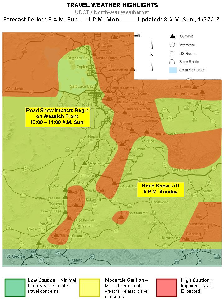
Here is UDOT'S take on the approaching storm


So lets get down to business with snow amounts, today-tonight's storm keeps trending snowier in all models, and slows the front down across N. Utah that is why the nws has upgraded the nothern wasatch mountians and valleys to a warning, click here to visit the nws page current thinking for the valleys is that Farmignton north will get the goods prob. anywhere from 5-8"+, but if the front stalls a little bit further south then places like Bountiful and Possibly SLC will receive more, for the rest of the Wasatch Front my guess would say 3-6 inches, but as i said the last 2 models have generated quite a bit more, so don't be surprised to see 8+. 

A bit of a break Monday afteernoon and night then the 2nd storm moves in, this will be a diffrent type of storm which will be a warm advection, which is when there is no front associated with it, just lifting of the low levels of the atmosphere, these events are hard to predict amounts but current thinking is 3-6"+ in the valleys, with a another light snow event on Wednesday. Enjoy


As for the Wasatch Mountains, looks like a good 8-14" with this 1st storm, them a 5-10" with the 2nd storm on Tuesday which adds up to 1-2' feet of snow, great skiing days on Monday-Thursday!


Sunday, January 13, 2013

Coldest in nearly 20 years in Utah Tonight


CLICK HERE TO GET THE LATEST TEMPERATURE FROM SLC INT L AIRPORT


Tuesday, January 8, 2013

Winter Driving Conditions Expected Thursday Eve.-Friday

There is a good chance of Very Dangerous Road Conditions for the Thursday evening commute as well as Friday morning's, below is a graphic from UDOT concerning this potential!

 
Statewide Road Snow Event
Thursday and Friday


 Snow amounts: Right now computer models are all over the place with regards to amounts, i will go with  4-8"+ in the valleys with the possabilty of much more if the DLE (dreaded lake effect ) sets up over a certain area, Benchs 6-12"+ and Mountains 1-2'+. Enjoy


Sunday, January 6, 2013

Inversion's for a few more days then SNOW!


 How cold has it been at the Salt Lake City Airport over the past week? Temperatures have averaged 6 to 16 degrees below normal since December 29th. The biggest departure from normal was January 5th, with the temperature averaging 16 degrees below normal.

Pic taken at noon on Sunday the 6th
Just a quick note on this inversion As PM2.5 levels continue to climb this week, it would be interesting to see how this event compares to others during the past decade.  Based on the PM concentrations above, it seems this is an event for Utah and Salt Lake Counties that is getting up there amongst the worst events over the past decade.

 CLICK HERE FOR ANIMATED MAP OF LOCAL AIR POLLUTION

Alright now for the good stuff, 

Attention  turns to the next system which is timing its frontal passage for late Thursday/early Friday. We may start to see warm advection precip falling primarily in the high elevations ahead of the system as early as Tuesday. Accumulations should be light on Tuesday and Wednesday until the main system approaches on Thursday. As of right now this system is looking very solid on both the GFS and Euro. It doesn’t have the most moisture in the world, but it has a strong front, lots of cold air and instability behind the front, and relatively slow movement. Not comfortable at this point guessing exact amounts but at least a moderate storm is likely.

Thursday at noon it should be snowing at a good clip

GFS and Euro both show a secondary system dropping into the area sometime around Sunday. This system will likely not be quite as strong but will bring in another shot of cold air and snow.

Sunday night's forecast


The other effect this system on Thursday/Friday will have on Utah weather will be to scour out the inversions. Don’t think we’ll get enough air flow to do much damage to the cold pools on Tuesday and Wednesday, but by Thursday we should see the cold air and pollution start to blow out. Again, this system is of a cold nature, so don’t expect the valleys to warm up too much, but at least we’ll be able to see across the valleys again by Friday.

Hopefully this all pans out and relives us from this unhealthy air, we will update as we get closer!  In the meantime head up and hit the slopes which still have great conditions, and believe it or not it is warmer at the resorts than the Wasatch front. Enjoy


Long range:
CFSv2 and long-range GFS and Euro point to possibility of us returning to ridging during the third week of January (15-21). Uber-long range models are hinting at this ridging breaking down during the last week of the month with the storm door possibly opening. Now this is all very speculative but it’s always worth noting. December long-range forecasts turned out to be pretty accurate so . . . who knows!